by Lin McNulty
BREAKING NEWS

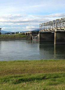
Both north- and south-bound lanes of I-5 bridge collapsed into the Skagit River this evening, May 23
Memorial Day travelers on I-5 at milepost 228, north of Mount Vernon, will find their route diverted this weekend. Both northbound and southbound lanes of the I-5 bridge over the Skagit River have collapsed.
The four-lane bridge fell into the Skagit River at approximately 7 p.m. on Thursday evening, May 23.
A vehicle heading south carrying an oversized load, 12 ft wide and 14 feet high, hit the bridge girders from the right-hand lane, and the northernmost span collapsed into the river, according to eyewitnesses, including truck driver Dale Ogden.
Preliminary reports indicate several vehicles were on the bridge at the time and that 2-3 were known to have gone into the water. Passengers have been rescued and transported to local hospitals. It is not currently known if other people remain in the water.
The WSDOT website simply reports a road closure: On I-5 northbound & southbound at Skagit River Bridge (MP 228) there is an incident blocking all lanes. The State Patrol has arrived on the scene.
Last Updated: 5/23/2013 7:20 PM
At milepost 228
U.S. Department of Transporation officials released a report on May 15 announcing implementation of a new robotic inspection tool to inspect structural integrity of concrete bridge decks that would incorporate customized imaging technologies to “see things humans can’t on concrete bridges.”
WSDOT officials did not readily know when the last inspection of that bridge, constructed in 1955, was accomplished.
According to the 2013 Report Card For America’s Infrastructure:
- 366 of the 7,840 bridges in Washington (4.7%) are considered structurally deficient.
- 1,693 of the 7,840 bridges in Washington (21.6%) are considered functionally obsolete.
- Washington received $146 million from the Federal Highway Bridge Fund in FY2011.
Washington State Patrol and Department of Transportation personnel are on the scene to conduct rescues as well as what promises to be an ongoing investigation.
Southbound traffic is being routed off at State Route 9, while northbound traffic is being routed off at George Hopper, according to WSDOT.
Rep. Rick Larsen, WA-02, issued the following statement following the collapse:
I am monitoring the bridge collapse in Skagit County. My office stands ready to assist emergency responders and local and state officials. I encourage people to follow police instructions and stay away from the site of the collapse to let first responders address the situation safely.
**If you are reading theOrcasonian for free, thank your fellow islanders. If you would like to support theOrcasonian CLICK HERE to set your modestly-priced, voluntary subscription. Otherwise, no worries; we’re happy to share with you.**


Thanks Lin…your article was the first one I’ve read which indicated the cause of the collapse…I appreciate your digging!
The infrastructure of our country is collapsing and maybe this kind of result will finally rally people to get behind a movement to shore up the parts of our country that need desperate help with people helping people, jobs created to fulfill the work needed to be done, and, we can build the greatness of this land once again together. This land is your land, this land is my land . . .
Recommended route to/from area South of is Best Road, map: [link removed by Orcas Issues as possibly corrupt].
For coming from North, usual Hwy 20 should work, but route via Bow may avoid congestion (and be more scenic), map: [link removed by Orcas Issues as possibly corrupt]
Latest updates on SJC DEM Facebook Page: http://www.facebook.com/sanjuandem
I’ve taken the Conway/La Conner/Best Road “detour” for years and made better time than I-5/Burlington/Hiway 20; except for when Tulip Season brings out flower-loving tourists, now over for a year. More scenic, one of my best-kept secrets until now.
Margie, we used to go that way all the time before COSTO came along and tempted us with its low gas prices. Lately though I’ve started using it again, and its beautiful farm land and easy driving certainly bring back memories of the old days.