Planners zoom in on Service Light Industrial (SLI) zoning
–by Margie Doyle —
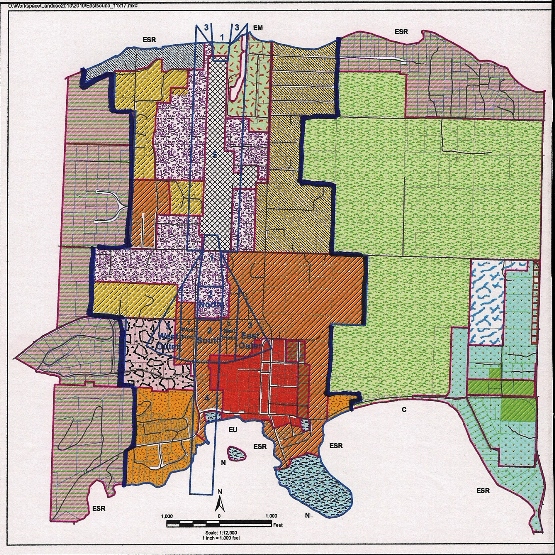
Corrected on Nov. 4 at 12:45 p.m. Eastsound zoning, 2014. The red outer lines define the Eastsound Sub-area. The bold dark blue lines define the Urban Growth Area (UGA),. The grey cross-hatch area in the center is the airport zone and the lavender-colored areas are Service Light Industrial zones. (County Community and Development Department document). For more detailed maps, see the comment following the article).
Orcas County Councilman Rick Hughes called a public meeting in Eastsound on Wednesday, Oct. 29 to present the progress on the Eastsound Sub-area Plan Update. Hughes explained that the lengthy process’s “original intent was to have a better definition of what we can and can’t do. ….to plan infrastructure and land use for what we think the future will need.”
One of the key goals of the subarea plan update, Hughes said, is “to take it out of the County Comprehensive Plan (CCP) and place into the Uniform Development Code (UDC) so we can make changes quicker.”
Gulliver Rankin, recent past chair of the county advisory Eastsound Planning Review Committee (EPRC), said the update will make county laws regarding zoning and development,“more active and responsive to community-driven policy now; where we can take small steps.”
Senior County Planner Colin Maycock elaborated on some of the changes that are proposed, in allowable uses in Service Light Industrial (SLI) zones, in signage, and in four areas proposed for re-zoning. The discussion intensified as the audience parsed the plan’s changes to regulations for allowable retail uses in SLI zones.
Currently regulations allow “retail with substantial storage space or incidental another allowable use” in SLI.
Proposed regulations read:
” Retail sales are allowed in the SLI district provided one or more of the following conditions are met:
- Retail products sold are manufactured at the same facility;
- Retail is associated with the part of the business that requires substantial storage;
- Retail is related to one or more allowable uses. “
Leith Templin, property owner, asked about the permanence or changeability of such regulations, which, once the update is approved by the council, can be changed by the County Comprehensive Plan Process.
Another questioner asked if “assemblage” could be considered in the definition of incidental use, and Maycock quipped that one could say that a hamburger requires assembly. That comment led to a scrutiny of the definitions of eating and drinking establishments.
Another concern was the potential effects on businesses already operating. Hughes said, “Retail has not been defined. As a community, this is important to define as clearly as possible. As a hypothetical possibility, an automotive shop operating next to Random Howse and the Post Office, “disrupts everybody around if it’s not zoned properly,” he said. He repeatedly asked that the public communicate their opinions and concerns to him so that he can get a sense of what the community desires. (He can be reached at rickh@sanjuanco.com)
Errol Speed, owner of Smith and Speed Mercantile, challenged the county officials regarding a survey to solicit public opinion in updating the plan, and Maycock replied that Speed had mis-read the development of new updates, “It says something quite different.”
Steve Pearson. owner of Orcas Rental and Saw, said the core of the discussion was to decide whether “competition is good or bad, otherwise it’s just efforts to push agendas. Until we deal with that, we can’t deal with what the rules are. We’re all dancing around trying to be politically correct.”
Becky Greaves, Orcas landowner, cautioned about increasing allowable uses in SLI zones, saying that there is only a limited amount of land designated SLI, and “once’s it’s gone, it’s gone. So it’s important to think about.”
Nearly an hour into the meeting, the public comments addressed individual circumstances and unique applications of current regulations, to the point where one person in the audience observed that it was impossible “to set down on paper everything that the human mind can think of. What should be done is set down general principles and ask what is reasonable?”
His opinion was seconded by another attendee who asked, “What is the purpose of all this verbiage? It’s totally unnecessary in this itty-bitty community.”
Maycock answered that the purpose of the meeting was “to clarify proposed changes in the current process… to maintain a separation between incompatible uses.”
Hughes gave the example of a proposed greenhouse to cultivate marijuana on San Juan Island, saying, “It’s not an issue until a huge growhouse shows up in your neighborhood.
“We’re looking at what we have on a consistent basis and asking ‘Is it still right?’ Or is it discouraging to entrepreneurs?”
Clyde Duke, owner of Random Howse and Duke Contracting Services, a roofing company, said, “Id’ like to speak to it the subarea plan: It’s working. It has rough edges. How do you clean it up?”
The challenge comes in the interpretation, Duke said; to permit or to enforce? “It becomes a burden on the person with a lack of time and money – the entrepreneur.”
Maycock said “Potential allowable uses [in the Sub-area Plan update] are very broad. In most instances, that broadness is unfair to the applicant, because he or she doesn’t know for sure what will be allowed until the public hearing.”
Patty Miller, property owner, former EPRC member and County Councilwoman, emphasized that the update, which has been considered by the EPRC and the County for over five years, was an administrative process to separate the Uniform Development Code and the County Comprehensive Plan to “make the process down the road easier and simpler.” She observed that not having a “redline version” [where the changes in the plan are pointed out], makes it really confusing.”
In answering a question about the proper forum for broader discussion of the allowable uses in specific zones, Hughes said that the next step in the subarea update process is to go before the Planning Commission and then to the Council. He would like to hear from the public in another Town Meeting before the Planning Commission next meets to review the update.
Signs
Three locations have been designated for a-frame signs in Eastsound:
- the corner of Lovers Lane and Main Street,
- the corner of North Beach Road and Mt. Baker Road,
- the corner of North Beach Road, Prune Alley and School Road.
While some said they liked seeing all the signs on street corners, others decried the proliferation of for-profit and political signs.
Map Changes:
- Lots between Landmark Inn and Washington Federal Bank on Main Street which are deemed “inconsistent,” to be changed from Village Residential to Commercial;
- Land behind the Outlook Inn and the Twin Towers changed from Village Residential (12 units per acre) to Eastsound Residential (4 units per acre), not commercial; offices allowed only with home occupation;
- Split-zone property owned by the Port of Orcas and used as a dog park at the NW corner of North Beach Road and Mt. Baker Road.It was noted that the corner property could have a 10,000 square foot building on it, like the religious institutions that occupy the SE and SW corners of that intersection. The Port has a master plan to develop parking there; EPRC supports keeping that property as a buffer;
- Klein properties in the northeast corner of the Eastsound sub-area don’t meet the current rural definition but are consistent with R-5 adjacent parcels.
Many of the particular specifics brought up in Wednesday’s discussion will be addressed during the update of the County Comprehensive plan. Maycock said that he expects the county to update the Comprehensive Plan in 2015. As the meeting drew to a close, people in the audience asked for a summary of the content and changes of the update.
It was brought out that Maycock’s Staff Report, which summarizes the changes, to the Planning Commission before its next meeting, now scheduled for sometime in January, will be available to the public through email address sign-ups at all public meetings, and through the county website, www.sanjuanco.com.
Similar reports have been completed and distributed by Maycock as the county works with the EPRC to update the plan. Documents can be found at sanjuanco.com/cdp/EastsoundSubareaPlan.
**If you are reading theOrcasonian for free, thank your fellow islanders. If you would like to support theOrcasonian CLICK HERE to set your modestly-priced, voluntary subscription. Otherwise, no worries; we’re happy to share with you.**





Hello,
Thank you for the thoughtfully detailed reporting of last weeks “Town Hall” meeting. Your stories on the Eastsound Plan Update have always been scrupulously fair and thorough.
I’m sorry but I must respectfully point out that the map posted does not reflect the current UGA boundaries. The parcels north of Bunny lane, in the northwest corner are part of the UGA. Current Subarea plan maps showing the UGA border and zoning can be found at https://www.sanjuanco.com/cdp/docs/Eastsound/Eastsound_2011-01-26-11×17.pdf
I appreciate all your efforts and thank you again for your hard work on this complex subject.
Editor’s note: Thank you Colin, the corrected map boundaries are now shown, as of noon on Nov. 4).
Why is the existing Eastsound SubArea Plan already off of the SJC website, and referenced only by a link to an outside website? Why were the maps changed before the fact? This grossly misinforms the public, and they have no way to compare existing to proposed regulations. On the SJC website Home Page, Eastsound Subarea Plan isn’t even referenced. We are proposing huge changes here, folks – this is irresponsible toward the Public you say you want to be involved. The rest will come in a letter to the Editor and I hope my questions and concerns are addressed there.
Thank you Patty Miller – I also am greatly confused by not having ONE document that is a redline version showing existing and proposed regulations. There is not even any referencing in the draft to where in the existing document the changes pertain. The numbers also do not correspond. It’s all confusing, even to people who know the old document.