
— by Margie Doyle —
As your Community-Journalist-in-Chief, I have an apology to make for the scarce coverage Orcas Issues has given to the County’s Shoreline Master Plan update. I confess it hasn’t been a top priority with the Eastsound Subarea Plan update, Managing Editor Lin McNulty’s 12-day hospitalization (thank goodness she’s back and bright!), off-island travel for family necessities, and even two weeks of that cold that’s going around.
Meanwhile, the County Department of Community Development and the Council have been hard at work updating the complex Shoreline Master Plan. There will be a public hearing on the update on Nov. 30 in Friday Harbor.
So now at the 11th hour, I’d like to direct your attention to the update and its proposed changes, and ask you to consider the impacts such changes will make to the county and contact your council members if you have concerns — or compliments — on the work done so far.
My great apologies for being a last-minute reporter.
Margie Doyle
Background:
“Until about 40 years ago, development along Washington’s shoreline tended to be piecemeal and uncoordinated. To improve and protect shoreline values and benefits, the state Legislature passed the state Shoreline Management Act in 1971. The public adopted the Act in a 1972 referendum vote.
“The state law established a cooperative relationship between local governments and the Washington Department of Ecology. The Shoreline Management Act applies to most streams, lakes greater than 20 acres, and marine waters as well as associated shorelands, wetlands, and floodplains.” (To read more background go to https://sanjuanco.com/CDP/docs/SMP/DOEFAQ-2011-10-26.pdf )
For those who would like to dive a little deeper, here are links form County Senior Planner Colin Maycock
— from Colin Maycock, San Juan County Senior Planner —
“I realize that finding the most recent shoreline documents on the county’s site for the Shoreline Master Plan (SMP) site could be made easier.
To that end I have posted the all the SMP documents pertinent to the Public Hearing at the very top of the SMP Document page: https://sanjuanco.com/smp/smpdocs.aspx . These are not different documents [from those that have been previously posted].
You can find the Goals and Policies here: https://www.sanjuanco.com/CDP/docs/SMP/2015-08-26_PC_Staff_and_CC_SMP_Draft-GPs_No6_final_edit_pn_and_cm_reviewed.pdf
You can find the Restoration plan here: https://www.sanjuanco.com/CDP/docs/SMP/2015-07-16_DCD_Staff_Draft_3_Restoration_with_appendix_and_maps.pdf
You can find the Ordinance containing regulations here: https://www.sanjuanco.com/CDP/docs/SMP/2015-11-10_DCD__Maycock_ORD_CC_PH.pdf
You can find the proposed San Juan Island map changes here: https://www.sanjuanco.com/CDP/docs/SMP/2015-11-10_Peihl_San_Juan_Landuse_with_Proposed_SMP_PH.pdf
You can find the proposed Orcas Island map changes here: https://www.sanjuanco.com/CDP/docs/SMP/2015-11-10_Peihl_Orcas_Landuse_with_Proposed_SMP_PH.pdf
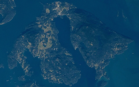
At the link below, you will find a map book that displays all of the proposed amendments of the shoreline designations in relation to Critical Areas and upland land use designations.
There is a legend to assist with the upland designations. The first map of Patos, for example, appears almost entirely ‘blue’. On the legend, the corresponding color is that of the “Natural” land use designation.
The corrected version of the map book we sent out earlier.[with] the legend … made clearer. https://www.sanjuanco.com/CDP/

**If you are reading theOrcasonian for free, thank your fellow islanders. If you would like to support theOrcasonian CLICK HERE to set your modestly-priced, voluntary subscription. Otherwise, no worries; we’re happy to share with you.**


So… is Colin linking just the proposed SMP? That’s all I can find on the website. Where are the Existing SMP and Comp Plan elements – goals and visions? Can we get electronic copies of the full existing documents and all existing maps? What about existing maps and the original and existing SMP documents and goals & visions – Where are those linked? You can’t know what changes the proposed SMP makes, without having the existing SMP to compare notes.
Can he make that easier for the Public too? and perhaps sooner than just before a hearing right after a holiday weekend?
“I realize that finding the most recent shoreline documents on the county’s site for the Shoreline Master Plan (SMP) site could be made easier….”
When did this realization happen, and when was corrective action taken, in this latest draft?
I don’t want to just see the map changes. I want to see EXISTING maps and plans and the EXISTING (unadulterated) Comp Plan – on the County website, on the Home page. There are far too important to not realize that they are hard if not impossible to find, and have been so all through this process.