
— by Sadie Bailey —
On Saturday morning, September 23, I was working outside at Lavender Hollow Apartments, where I live. I heard sounds of an excavator tearing up the forest, for several hours. The sounds were horrible and painful to hear. I went to investigate, just as an engineer was taping off the trail with “trail closed” signs. I walked up the trail, and what I saw was devastating to me: The forest I love and view every day was being destroyed and uprooted, stumps and all. This is how I learned about the Airport Vegetation Removal Project.
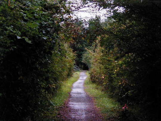
April 2017: Trail south of the airport from Mt. Baker Road to Enchanted Forest Road
Unfortunately, we’re also in the flight path. Lavender Hollow never should have been built there, but with the Urban Growth Area, all conservation areas laid out in the Comp Plan have been ignored, and have, or will soon be, destroyed. If the Conservancy Overlay were honored, this may have been avoided or at least not this radical. This hurts my heart greatly.
I have begun reading the 301-page Environmental Assessment(EA) and Findings of Non-Significant Impact (FONSI) for the Airport Vegetation Removal Project. By the time I get all the answers I seek, the trees will likely all be gone.
I’m not the only person upset by these impacts, since many people use the trail and no one seemed to know this was happening, including the Eastsound Planning Review Committee (EPRC). The only article I saw about this Project was after the fact, when I did a search on Sunday and found Tony Simpson’s submission to Orcas Issues dated September 19, and the Port’s submission to the Sounder dated Sept. 25.
I understand that the need for safety for airplane pilots and their passengers is the primary focus of this project, and I also believe that we who are directly impacted by the flight path also have needs for safety and quality of life – and we need to stand up for the non-human living things that have no voice to speak.
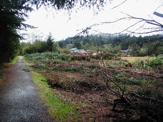
Sept. 2017: trail south of the airport from Mt. Baker Road to Enchanted Forest Road
The scope of the project is of huge impact, regardless of what the EA states, and some things are missing from the assessment, such as wind tunnel issues and potential flooding of multi-family units south of the project. (Multi-family units are NOT listed in the EA as housing potentially impacted by this project.
These are my immediate questions and concerns that come to mind: (likely more to come)
1. Adequate stormwater control and potential adverse impacts- especially for Lavender Hollow apartments, directly south of the project.There will be no tree filtration to hold back the water. (I can provide documents on the difference between tree filtration capacity and grasslands filtration capacity – if need be. Mowed grass areas/“lawns” are considered to be impervious surfaces.)
2. Potential flooding of Lavender Hollow apartments; plus the too-small culverts where Enchanted Forest Road crosses the creek.The culverts are filled with silt and debris and the water cannot flow.
3. Creek disturbance north of the saw shop, since the creek runs to Mount Baker Road in the wet season (stump removal could re-route that water).
4. What measures will be used to keep back silt – and nitrates from dog waste on the trail from getting into the creek, with no trees and shrubs to hold them back?
5. Silt intrusion into the creek crossing Enchanted Forest Road – what will hold it back?
6. No one talks about WIND when discussing impacts: a wind tunnel is being created in an already fierce wind tunnel land mass (Eastsound Basin – a narrow land mass becoming devoid of tree protection due to development.) This project will exacerbate strong wind issues in this area, and directly impact us with dust and debris in summer.
7. Light pollution in general – badly affecting bird populations and migration. Light pollution from airport and elsewhere that will likely adversely affect Lavender Hollow residents on the north end of the complex – plus ugly views of transformer on Lovers Lane and Airport search lights and other high intensity lighting – with no visual buffers.
8. Increased light and temperature shifts affecting amphibian populations and further warming the waters, with no shade in summer to prevent evaporation and worse drying of the soil, nor shade from the hottest sun of the day for trail users.
9. Use of herbicides if control of noxious weeds seems to not be working – and what that would do to groundwater and water quality.
10. Separation of the contiguous wetland of Eastsound Swale into 4 wetlands and separation of creeks that used to all be one creek, one high-functioning wetland – and not treating the watershed as a whole – misleading to the Public.
11. Potential impact of planes flying even lower and closer to Lavender Hollow apartments than they already do now, with no trees to keep them up higher. They almost graze our rooftops in the north buildings now. Many of us are losing our hearing due to increased plane and jet noise. We are concerned about closeness of the airplanes to our homes and of potential disastrous crashes into them. It seems the trees were helping the planes fly higher and miss our rooftops. What will stop them now? What would buffer a crash, if not the trees?
12. Loss of large areas of habitat for birds and other species, and the proliferation of rabbits and introduced hares in the grasslands and infiltrating town (already starting to happen)
13. I don’t see why the trail needs to be closed, outside of work hours, for 45 work days! People should have the right to see and get used to what is happening. I ask that the trail remain open before and after work hours and on weekends.
14. Will all the trees west of the trail will be cut ALL THE WAY from Mount Baker Road to Enchanted Forest Road – and how much more deep woods will be cut on the East side of the trail, near where it makes the L bend? There are survey stakes all the way to the house. What will happen to the creek itself on ECR? Will that be clearcut too?
15. The mitigation plan for the south part of the Plan says that there will be no mowing within 25 feet of the creek, and that shrubs will be planted along the edges of the creek to protect water quality in Wetland “D”– the poor remains of the creek directly across the street from Lavender Hollow Apartments. Will this be done? Which shrubs will be planted along the creek edges, and what are the plans to protect the new plantings from rabbits and deer?
16. Many of these are cumulative impacts, and cumulative impacts are not well addressed in the EA.
As more people see this and realize what is happening, there are likely to be other upset [comments], and concerns from parties more expert than me. I speak mainly as an impacted resident directly south of the impacted wetlands trail in the south portion of the Plan. My objective is to be heard as an impacted resident in multi-family low income housing. I did not see multi-family housing listed as potentially impacted on the EA.
We have a major stormwater problem, due to continuous clear-cutting of forest and development in the Eastsound Urban Growth Area (UGA), the Airport Overlay District and the Eastsound Swale Conservancy Overlay District. This encroachment of development, forest loss, and tree filtration loss within the Swale all the way to Fishing Bay hurts our waters. We have lost a tremendous amount of songbird species, bats, and amphibians due to loss of habitat and infiltration of invasive flora and fauna and the above-mentioned; coupled with noise and light pollution. We never asked for a treeless CITY.
After years of watching wetland and watershed degradation, I have seen time and again the short-sightedness of “mitigation” plans for wetlands, and the failure to think long-term about cumulative impacts of imposing our will on the lands and waters. It’s a tiring and mostly a losing battle. But if any win-win or middle path can be effected to ensure success and enhancement of any so-called mitigation plan, and address concerns of negatively impacted residents – even now – it would be remiss, even at this late hour, not to try.
What happened to the protections of the Conservancy Overlay District? I ask Council and the Department of Community Development (DCD); HOW could this have happened? What answers can you possibly give that would give me comfort or hope, or help the trashed ecosystems or displaced creatures we see struggling daily?
This, and all that is happening to places such as Victory Hill, the big condo/deforestation project about to start south of the school, violates EVERYTHING laid out in the Comprehensive Plan for Eastsound SubArea Plan.I ask that everyone walk the trail, (before or after bulldozing hours, of course – or on weekends) and view these destroyed forests, and see with your own eyes what we will have to live with, going forward.

**If you are reading theOrcasonian for free, thank your fellow islanders. If you would like to support theOrcasonian CLICK HERE to set your modestly-priced, voluntary subscription. Otherwise, no worries; we’re happy to share with you.**


Reading your letter gave me an idea: There must be some kind of legal limit concerning airplanes and jets flying directly above residential homes and apartments..
There must be a state and federal restriction that should be invoked.
Who could overrule that?
The rules about flight paths are apparently what led to the clearing of the trees (though I can’t see why). As someone who has admittedly not researched this, it seems to me that the flight overlay covers way too much ground and overestimates the threat of very small general aviation. The trees are gone but hotels, apartments, and schools are still there in the path?
Whine all you like, the airport is as essential as the ferry system and has been located there many decades. The legal flight distance above houses is 500 feet, except when landing, so don’t expect any “state or federal restrictions” to be invoked. Airplanes have crashed on the southern approach to Eastsound before, so the trees are a real hazard and I support removing them!
Wow! No matter what side of the issue a person is on, your lucid and detailed letter was a pleasure to read because it provoked thought. Thank you for going to that much effort on this important topic.
I have lived in Eastsound for forty years. The airport, the flight path, and the trees have all been in the same locations for that entire time. How is it that, suddenly, the trees need to be removed?
At what point can we say that enough is enough? These ‘projects,’ ‘improvements,’ and ‘necessary tasks’ that sometimes stink of greed and power? How is it that so many special favors have been granted in this county? In this case, where is this leading us? Surely those trees had a reason to be there. Now that they are gone?
Another disturbing thing about this project was that the contract for tree removal was supposed to begin Monday 9/25 but this bulldozing was done Sat. and Sun. Sept. 23 and 24.
The project is supposed to be done, according to the contract, within 45 working days. Are weekends considered working days?
So many more questions arise. I encourage others to ask questions and keep asking questions on this and other projects.
So much has changed. For example: With no more CUPs (conditional use permits) required in the Eastsound UGA, property owners no longer receive notice if you are within 300 feet of a large scale project potentially affecting Critical Areas, transportation issues such as traffic issues, ETC. Notice is not posted in plain sight for the Public to view and question, and nowadays when I do a parcel search on the county maps, what used to be information available to the Public is not – for instance, when land gets subdivided or changes hands between LLCs – so much more is hidden and you need to do records requests on each individual parcel, it seems. (who has time or money for that?!)
With the upcoming Comp Plan “review”, now is the time to ask questions and do a comparitive of the original Comp Plan vs the new “revised” one – IF you can get the County to post the Original Comp Plan on its website (this tactic of “disappearing” the old so that no comparative can be made is business-as-usual for SJC.)
Some people can call this “whining.” I call this asking questions that the Public deserves to have answered and addressed.
As Ed observed, if the trees have not been a hazard before, how now? Further, in the case of Don Tompkins crash within the flight zone, i understand that the trees helped cushion his plane and may have reduced the severity of his injuries.
Sadie, thank you for noticing all the irregularities in how this clearing was done.
When I read Tony Simpson’s article several weeks ago, my immediate thought was “This is not going to be well received.” Driving through town yesterday I can see why! It felt as if that area is being scalped!!! I agree with those that are saying “why now?” If the trees were there last year and were OK, why are they not OK now? Are we trying to get larger and faster planes into our little airport? It would have been nice to be told what is going on….
The FAA defines the clearance requirements for Instrument Approaches into all airports in a document known as TERPS.
https://www.faa.gov/documentLibrary/media/Order/8260.3BCHG19.pdf
It is up to the local airport authorities to maintain all of the required obstacle clearances.
Sadie: THANK YOU!!! You are so clear-sighted in your presentation, even though you, personally mourn the loss of “old” Eastsound, and the reason you came here and have lived here these many years.
You have, also done so much research and investigation, that the rest of us don’t feel we have time to do.
What can “officials” and people involved in projects like this do to create the balance that’s needed, that you speak so well about??
Winnie’s and Ed’s comments resonate with me, also. I have read many times about trees cushioning planes that crash, and therefor possibly saving the pilot’s life.
Such is the life of unabated human development….this will get worse on Orcas…but much better than some of the other islands thanks to the brilliant foresight of so many Orcas folks who developed many land easements…we should protect more and prevent it from becoming a Catalina island, Nantucket, etc
Ed Sutton – Our overhead photograph from 1977 shows nothing like you describe. There is minimal vegetation along the roadbed that is now Enchanted Forest Rd, minimal vegetation where the Firs along Lover’s Ln now are and shrubbery in the ditch now called the Eastsound Swale. I would be happy to show you our photographs, but my engagement in this forum will not be extensive.
What is happening to Eastsound? Whitewashed Cracker Jack housing popping up, then Outlook Inn demolished a cabin and magically gets permission to build four cottages far beyond the original footprint of the cabin (how is that legal? I thought building on the waterfront was illegal beyond an existing footprint), and now clearcutting entire swaths of land without a nod towards the existing ecosystem?
While these trees have been there for a number of year, they have grown tall to the point of being a hazard to pilots. While landing to the north, I have noticed the trees just off my right wingtip for the past few years. A slight deviation in flight level or direction could put my wing into a tree, resulting in a serious or fatal crash. When the trees were shorter, this was not an issue, but it has become one of late. It is particularly hazardous at night when the trees cannot be seen. While I don’t like to see trees removed, I feel this was the right decision in the interest of public safety.
I’m impressed that this animated thread is really a continuation of the “Paul Revere” call, so well expressed in Joe Symons’ “Time Has Come” offering of Sept 25 in Orcas Issues; time marches on, and each local “improvement.” however well-intentioned, can just be another local domino, falling as we all watch! What happens next week?
I remember a talent show at the Orcas Center, early ’90s, when Bruce Harvie musically celebrated the latest Eastsound improvement with the newly-crafted song: “I want to spend Christmas Day/ on the Sidewalks of Orcas Island!”
Tempus fugit – to arms, to arms! Thanks, Sadie, thanks, Joe.
Thank you, Gil, for a pilot’s perspective about why the tree cutting is occurring. The rationale for the tree cutting was never described until your comment was posted.
First off, @Gil Blinn and other pilots here on Orcas: I’m not “against” pilots or pilot safety. I understand the need for pilot and passenger safety. I know that many pilots here do kind and generous things for islanders such as Mercy Flights – and we appreciate what you do for so many here on the island.
Regarding trees, I have a different memory than what is being written here. I moved to Orcas in 1981, and lived on Tom Lavender’s land (Lavender Farm) in the Rose Cottage in 1984. It’s hard to believe that the trees I looked at when living there grew that tall from nothing in 1970 – to tall trees I saw in 1984 – only 14 years. It’s inconceivable, but possible, because it’s ALL a wetland watershed, that trees could have grown much faster there because water was so plentiful.
Here are some memories of that time when I lived there:
The area was heavily wooded from Victory Hill north and west, (and East, where that woods north of April’s field will be sacrificed for “April’s Grove” housing project (why not in the existing field or something already clearcut? 100 year old apple trees can be moved with success; a forest can’t be put back.)
Eastsound Swale creek and north of there were thick with trees – a very deep, dark, wood; definitely “flashlight” woods! There were fields to the west of the creek area, and tall trees and willows all along Lovers Lane and Mount Baker Road. Enchanted Forest Road extension at that time was a heavily wooded dirt trail and the woods went a ways north and south of the trail.
Where the Funhouse is now was thick woods (and thanks to the Bullocks, has trees again) and all down the “dirt” trail was deep woods including part of the Christian School lands.
The creek had muskrats and other wildlife in winter, and was much wider in winter, before Enchanted Forest Road was punched through a 300 foot wide amphibian breeding habitat and dammed the creek so it couldn’t run anymore.
There were trees; it’s untrue that there were none. There were many trees where Lavender Hollow is now, and north all the way to Mount Baker Road.
I don’t have aerial pictures, but I lived there on the ground and walked the dark woods trail often, and I remember the lay of that land quite well. There were also thick woods to the north. The field East of the trail now being clearcut was a hayfield, and had few to no trees because Tom Lavender used to have it cut. There were plenty of full-grown trees in that area.
The more I delve into this, the deeper and more disturbing are my questions, because questions about this particular project have led to other more troubling questions, which I hope to ask sometime in the near future, in any public forum that will print them.
The Environmental Assessment shows conflicting map “figures”; one Exhibit 1-1, Vicinity Map, shows the area of the clearcut project does NOT extend all the way to Enchanted Forest Road. Exhibit 2-1 shows them taking EVERYTHING. Which is it?
I have been patient waiting for answers to these questions, and have still received no answers.
I’m still waiting. Meanwhile, the bulldozers and chainsaws are running.
I want these questions and concerns answered. I, and the Public affected, and the multi-family dwellers directly across the street from it, deserve the courtesy of answers.
Tony Simpson, Airport manager, called me and we had a long phone conversation. He took plenty of time to address my concerns and answer my questions to my satisfaction, and I left the conversation feeling much better about things, and with more understanding and knowledge about what would happen and how some of my concerns will be addressed.
I’m still so sad that the trees are going and the creatures displaced; that will hurt my heart for a long time. But I also felt heard, and that he understood how it must feel to be living so close to the project and seeing such major changes to the landscape that I love. I feel I can work with him, should there be issues in the future that we will need to address as a result of the project.