||| FROM SALISH CURRENT |||
Near the end of MacKaye Harbor Road on the south shore of Lopez Island is Agate Beach Park and a parking area for those walking in to the Iceberg Point San Juan Islands National Monument.

Same location, 10 years apart: the stairway to the beach (at left) has been washed away, leaving a notch in the shoreline. (SJC)
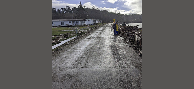
Early in January, high winds and a storm surge closed this section of road, and the county encouraged residents to stay home until a passable one-lane road could be cleared of water and driftwood. Portions of the road have been one-lane since 2018. This winter a stairway to the beach washed out, making the beach inaccessible.
San Juan County has been studying the road in this area for over 20 years and is exploring how best to keep access open. Most recently, a community meeting took place April 25 at the Lopez Grange Hall, with five county staff members and a full house of local residents.
County council member Jane Fuller welcomed the public and explained the county’s “realization of imminent sea rise and the need to insure that our infrastructure is resilient.” She pointed out that the county has identified 13 miles of roads throughout the islands that are under a similar threat, so this is “just the beginning.”
The section of MacKaye Harbor Road from Barlow Bay hugs the shoreline and serves as the only access to nearly 80 property owners, including tribal lands, and public lands. The shoreline bank next to the road by the park has been reinforced with rip-rap since the mid-’60s, and the county Public Works department has done several projects adding revetments, or shoreline armoring, to protect the road over the decades.
Tom and Sally Reeve, property owners south of Outer Bay, described some of the problems associated with the eroding road. Utilities are being uncovered including water lines, electricity and phone cables. “Even if sea level doesn’t rise another inch,” Tom said, “that road is going away.”
The area is also rich with cultural resources. According to a 2017 engineering report, “MacKaye Harbor Road Relocation Feasibility Study,” within a 1.0-mile radius of the study area there have been “40 cultural/historical surveys conducted, with 30 archaeological sites, six historic properties, and four Historic Register-listed properties recorded.”
The 2017 engineering report said that sea level is expected to rise in the San Juan Islands by 1.57 feet by 2050, and by 4.69 feet by the end of the century. That would increase the current highest observed water level (HOWL) from 10.3 feet in 2017 to 15 feet in 2100.
At its lowest, the elevation of MacKaye Harbor Road along Outer Bay is +13.5 feet mean lower low water (MLLW) — the average height of the lowest tide recorded at a specific site during a 19-year period — and Barlow Bay road is +11 feet MLLW. At the end of the century projected water levels, these areas would be flooded.
It’s complicated
The 2017 report identified options for dealing with the deteriorating road, ranging from doing maintenance on the existing roadbed for as long as possible, to exploring various options for moving the road inland. To date, efforts have focused on maintaining the road as-is, to protect access, but this is seen by the county as a short-term solution.
More recent efforts to obtain grant funding for longer-term solutions were outlined in plans presented by county staff at the April 25 meeting (view the video of the meeting here [1:23:13]).
Two grant applications totaling $7 million have been submitted to a NOAA (National Oceanic and Atmospheric Administration) program, as part of the Climate Resilience Regional Challenge. This is a 2023 federal program, and the first-ever regional approach to strengthening climate resilience. San Juan County has partnered with 17 entities, with Snohomish County as the lead, which as a group is seeking $72 million.

**If you are reading theOrcasonian for free, thank your fellow islanders. If you would like to support theOrcasonian CLICK HERE to set your modestly-priced, voluntary subscription. Otherwise, no worries; we’re happy to share with you.**