
Planning Commission meets Friday, Aug. 21 at 10 a.m. at the American Legion Hall in Eastsound
— by Margie Doyle, updated, correction August 16
“Does it represent the character of the community?”
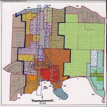
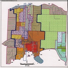
Eastsound Subarea, with Urban Growth Area (UGA) boundaries in dark blue. The grey cross-hatch area in the center is the airport zone and the lavender-colored areas are Service Light Industrial zones.
That was the question asked, both openly and implicitly, as four members of the Eastsound Planning Review Committee (EPRC) discussed its recommendations to the Eastsound Subarea Plan update which, after years of work by the EPRC and County staff will go before the Planning Commission on August 21 in Eastsound.
With notable assistance from Planner Colin Maycock for the County Development and Planning (CDP) department, the Subarea Plan, first adopted by the County in 1981, was divided into two document this past year:
At the regular EPRC monthly meeting on August 6, Chair Greg Ayers, Ken Katz, Fred Klein and Bob Maynard debated the plans in light of regulations outlined in the standards and compliance with the visions articulated. Absent from the August meeting were EPRC members Clyde Duke, Martha Fuller and Jobin Suthergreen.
Following a period of public comment, the EPRC discussed the proposed Comprehensive Plan Official Map amendments including:
- extending the Village Commercial designation along the north side of Main Street, (click here to see map)
- creating a new Eastsound residential district with a 12-unit-per-acre density in the Mountain View Street Area (click here to see map)
- split zoned parcels adjacent to the airport and along Bartel Road
The discussion of map amendments led into critical matters to come before the Planning Commission, (and ultimately the County Council) as Subarea Plan amendments, including:
- splitting land use regulations from the subarea’s goals and policies;
- amending and moving regulations to the Unified Development Code;
- making the subarea’s goals and policies an appendix of the San Juan County Comprehensive plan.
Maycock presented the staff report and six maps (click here) to illustrate and discuss the County Development and Planning (CDP) staff recommendations for the subarea plan update.
The existence and modification of “split zones” dominated the discussion, after the group had agreed upon extending the Village Commercial designation for properties east of Washington Federal Bank on Main Street; and upon creating a new Eastsound residential district in the Mountain View-Seaview Street area. This designation as a residential district “makes it more consistent with the rest of street designations between what is commercial and what is residential,” said Maycock.
The designation affects 41 lots, of which four are vacant, and “brings them into line with the existing neighborhood,” according to Maycock.
The first two changes were the easy part: next came the discussion of two instances of split zoning within the Eastsound Subarea which extends from Los Arboles in the west to Bartell Road in the east.
The first split zone discussed was property along Bartell Road. Maycock said that this split zoning came to his attention when he was researching other split zones on Orcas Island. Following the meeting, he said that his superiors advised him to include the Bartell lots in his recommendations to the Planning Commission.
This property is split between Eastsound Residential and Eastsound Rural zoning. Maycock said that there will be two options presented to the Planning Commission regarding this property:
1) make it all Eastsound Rural
2) make it all Eastsound Residential which CDP staff recommends
Maycock said the county had just learned of a State Department of Commerce opinion which “would not support having a rurally zoned parcel inside the [Eastsound Urban Growth Area.”
When EPRC member Ken Katz asked Maycock if he was “recommending a split parcel,” Maycock said he was, “under duress.”
EPRC member Fred Klein questioned, “If it doesn’t meet with the criteria of Eastsound Rural, why take [the matter] before the Planning Commission?”
Maycock replied, “Out of deference from a historical point of view.”
There was no agreement among the four EPRC members as to how to weigh in on the matter in advance of the Aug. 21 Planning Commission meeting.
The second matter of split zoning concerns the two parcels at the intersection of Mt. Baker and North Beach Roads. (to see map, click here). One of the parcels is owned by the Port of Orcas. Maycock said that county staff had been directed “not to create split zones in the absence of clear physical boundaries.” However this property is one example of such zoning, with part of it zoned Eastsound Residential, and the other part zoned service light industrial zoning (SLI).
This parcel was purchased with 95% funding from the FAA and 5% funding from the Port of Orcas. The Port of Orcas tax district only encompasses Orcas Island, not the county. Taxes typically represent about 50% of Port revenue, so it would be most accurate to say that Orcas Island land-owner taxes paid for approximately 2.5% of this parcel. (Thanks to Port Manager Tony Simpson for this correction.) Maycock said the report to the Planning Commission proposes “to adjust the split zone and make the parcel all service light industrial.”
Katz repeated Maycock’s earlier rationale in suggesting that the property, which is bordered to the north by residential zoning, be made all residential, “in deference to the past?”
EPRC member Fred Klein said that deciding upon the proper designation for split parcels “should be a planning decision, not at the convenience of an individual property owner.
“In some instances, particularly in an urban village, the character of an intersection is more important than dividing it along a street.” Klein further recommended preserving the character of that intersection, and suggested that it be stated in the Goals and Policies section of the Subarea Plan, “When it is important to retain the character of Eastsound, we will allow split zoning within the village.”
Klein asked if such a direction “would be followed or would it be trumped?” by the county Uniform Development Code. Maycock said that the Subarea Plan “controls contradictions within the UDC.”
However, Councilman Rick Hughes noted that the goals and visions document within the Subarea Plan update needs to be approved by the County Council.
The EPRC members were unanimous in their opinion that the properties should remain split-zoned. They asked that their opposition be noted in the presentation to the Planning Commission, and Hughes added that the Port of Orcas, as owners of the split-zoned property, and as another government entity, may advocate that the land be rezoned to all SLI.
EPRC member Ken Katz called attention to the mechanized speed control signs that have been installed on Orcas Road by Fowler’s Corner and in Moran State Park. Katz questioned whether the signs are out of character, historically, with the signage allowed on Orcas Island. He also asked whether the blinking traffic signals were in compliance with the lighting ordinances.
The EPRC committee was advised that in matters of public safety, traffic lighting and control signals are exempt from regulations.
Bob Maynard remarked that he was “impressed by the amount of regulation and the absence of judgment” regarding the Subarea Plan update. “There has to be judgment, in my opinion,” he added.
Eastsound Sub-area Plan
The Eastsound Subarea Plan is a part of the County Comprehensive Plan and was written to provide both a vision and development requirements for the UGA and the properties from Los Arboles on the west to Ship Bay on the east. (Last summer the Plan was separated into two documents, one for development standards and one to articulate the vision).
The Eastsound Sub-area Plan was accepted by the county in 1981, before it agreed to comply with the Washington State Growth Management Act (GMA) in 1999, which superimposed new regulations on growth in the county. Part and parcel of GMA compliance — achieved in 2009 — was establishing an Urban Growth Area in Eastsound.
This month the county is moving forward to complete the adoption of the Eastsound Sub-area Plan update this year. Last week announcements were mailed out of a public hearing with the Planning Commission on the 21st of August at the American Legion Hall on Crescent Beach road beginning around 10 am.
Earlier this summer, County Senior Planner Colin Maycock told the Eastsound Planning Review Committee (EPRC), “We will be using the text approved by the EPRC in July 2014 as the hearing document. …. The EPRC is free to suggest further changes to approved draft, … addressed to the Planning Commission.”

**If you are reading theOrcasonian for free, thank your fellow islanders. If you would like to support theOrcasonian CLICK HERE to set your modestly-priced, voluntary subscription. Otherwise, no worries; we’re happy to share with you.**


Thank you, Leif, the link now works, please take note that it refers to a group of documents and you may need to browse through to find the information you are seeking — it’s not just one document.
Somehow we survived without the blinking traffic speed sign, yet it is now a matter of “safety”–which means the public isn’t asked and complaints are futile? Will the same thing happen when our mainland-minded safety experts propose a traffic light? I think Council should (1) get a rural element done for our Comprehensive Plan to help protect our rural character and (2) require that there be notice and a hearing before these kinds of actions.
I find the blinking speed sign ugly and out of character–I had hoped that it was temporary. How it’s a safety issue is beyond me. The 20 mph signs are more than sufficient.
Peg, I think you’re the only one who goes the speed limit here! It’s amazing how these signs have worked to slow down traffic!
We have until the end of 2015 to get out of the Growth Management Act and come up with a truly balanced plan that DOES represent the character of this community. My biggest question is why we seem hellbent on an Urban Growth Area in a rural island?
Does making Eastsound into a light-polluted, treeless desert with buildings squashed together like sardines, flooding in town and desert conditions in drought-time, seem in character or compliance with the character of the community and the Pacific Northwest? What character was left to the “community” with this rewrite of the SubArea Plan, besides more and more commercial ventures and cutting down our last forests to squash in more affordable housing, when everything that made Eastsound beautiful gets clearcut and the slain trees sold off for lumber profit? Is this really in character with the vision that we who love this island have in mind?
How does separating out goals and policies from regulations help the Public know what the original, balanced vision even WAS? Bollocks!
continued:
Ironically, those least able to pay for sewer and water hookups will bear the brunt of this expense, too – the prohibitive hookup charges for sewer and the monthly bills for sewer and water. This may seem offensive to some – too bad. I don’t call any of this representative of the working people of Eastsound who must pay for these required services. Look at what happened to the residents of Bonnie Brae.
Now every tree is getting cut further and further out of the Village, further and further uphill. What will happen when our boom economy goes bust? What then of all those empty storefronts and real estate offices? We can’t put back the mature trees. What will hold back silt erosion? Stormwater? Flooding? Should we feel placated that “no worries, we will pipe all the excess water out into the ocean,” and kill the rest of the trees in the process by depriving them of groundwater?
Will we destroy every functional wetland to make room for more BUILDINGS? Will we cut down all trees on Port property to get rid of the birds, so that no jet planes might hit a poor little migratory bird?
Why can’t Eastsound and its surround still have a conservancy Overlay District? Why can’t we have trees? Wetlands? WAKE UP, people – while you still can! Fight for the right to have nature and beauty be a part of our Plan!
If I ask questions or challenge these misguided views, I am shut out and shunned. How do you think that feels? Does it fit the character of our community? I invite Colin Maycock and Council and the PC to look in the archives at all my letters as far back as they were kept, and maybe actually READ them. I sent reports, documents, pleas that were likely never read by anyone. If i seem rude and enraged, I am – from years of grief and sadness – that is what comes from watching the community of Eastsound be sacrificed for dollars. Now I am only broken hearted and can watch no more tree carnage!