Important update for islanders. Please help spread the word.
||| FROM BRENDAN COWAN for SJC DEPARTMENT OF EMERGENCY MANAGEMENT |||
Island residents and businesses who are planning on mainland travel this week should be aware that the flooding forecast for Skagit County may impact both Highway 20 and I-5.
The peak of the flooding in Mt. Vernon is currently forecast to occur at 4am on Friday December 12th. It is not clear exactly when or if flooding might impact the highways, but it could potentially occur during the day on Thursday December 11th.
Islanders are strongly encouraged to delay non-critical travel until after the flooding has receded and it has been confirmed that the roads are open. Road conditions are available on the WSDOT map at: https://wsdot.com/Travel/Real-time/Map/
While the water is forecast to go down fairly quickly, if roads are impacted, it may be some time until roads open depending on the severity and duration of the impacts. Do not ever try to drive through a flooded roadway.
Skagit County Emergency Info is online at: https://www.skagitcounty.net/Departments/EmergencyInformation/main.htm
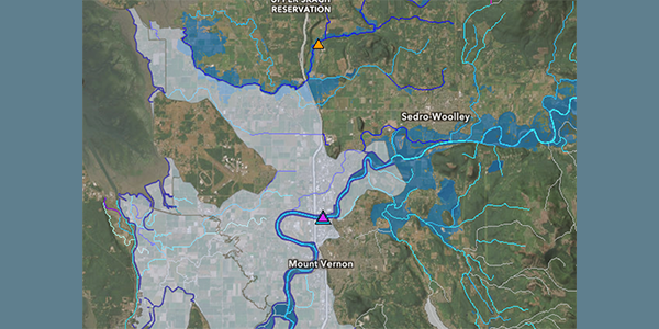
Map shows areas vulnerable to flooding (blue) and areas protected by levees or dikes that may be vulnerable in this event (grey)

**If you are reading theOrcasonian for free, thank your fellow islanders. If you would like to support theOrcasonian CLICK HERE to set your modestly-priced, voluntary subscription. Otherwise, no worries; we’re happy to share with you.**