
— by Margie Doyle —
A great part of the Aug. 2 Eastsound Planning Review Committee (EPRC) meeting was dedicated to presentations by county Public Works Engineer Shannon Wilbur, describing draft plans for Streetscapes in Eastsound.
History
She introduced her presentation by recalling that the revision of the goals of the Eastsound Subarea Plan (ESUP)as far as transportation called for development of a transportation plan that addresses and enhances the character of Eastsound. As defined by ordinance in 2015, developers are responsible for sidewalk, curbs and gutters for any development to provide:
- Safe pedestrian access
- Safe vehicular transportation
- Provide parking in village core commercial area
(The only development planned for the east side of North Beach Road in this area is OPAL’s April’s Grove 45-unit rental development. OPAL Representative Jeanne Beck said that OPAL could not afford the streetscape development standards as they currently stands.)
Eastsound needs to look ahead to determine future needs, Wilbur said. “It’s much easier to plan ahead now than to operate in a crisis mode; to try to get ahead of the curve: you’ve already done that,” she told the county advisory committee. She presented schematics of possible configurations of several stretches of road under consideration.
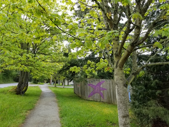
Current path along west side of North Beach Road between Mt. Baker and Enchanted Forest roads
North Beach from School Road (where North Beach Road turns to the east and continues north), to Mt Baker
Wilbur described that stretch of road as “a main transportation corridor, funneling into village of Eastsound; a gateway from the north into the village. Currently there is a walking trail is on the west side of the road.
Wilbur said that Public Works is in agreement with EPRC about having a separated path along the east side of the road; and proposes the addition of 4-ft shoulder to provide for bicycles;and pervious concrete for the trail.
Concerns about safe access for students; comparisons of gravel to pervious concrete trails; maintenance of the current pervious walkway east along Mt. Baker Road from its intersection with North Beach Road; and retaining the established trees along that stretch of road were aired.
County Councilman Rick Hughes commented on the Streetscape Plans, “Part of the reason we’re doing this is that looking at standards that applied to the whole village, there was consensus that each section should be looked at a little differently.”
EPRC Co-chair Margaret Payne expressed appreciation for the changes Wilbur proposed that evolved from “our concerns expressed at the last meeting.”
Wilbur said, “It’s a compromise form what Public Works would like to see on a particular road; we were outvoted on parking [suggestions]; we were told “no” last time. As to plans regarding [North Beach Road] from Enchanted Forest Road to School Road, we know that parking [along the roadway] is not supported at this time. We did hear you and this is the compromise Public Works is proposing
“We would love to engage in a more holistic look at parking options in Eastsound. We keep saying no; where do we say yes? What’s the least bad option for parking?” Wilbur asked
Tony Simpson suggested expanding the shoulder, and creating a shared, dual purpose (pedestrian/bikeway) path. Wilbur responded that such a design “would have benefits and impacts; we don’t have one like that in the county.”
Toby Cooper supported a deviation of pathways to go around big trees: “We don’t have to live by straight lines.”
Jeanne Beck suggested that a bike path on both sides of road as a chip-seal travel lane; with only the pedestrian trail being a pervious surface.
EPRC Co-chair Paul Kamin considered that the county could acquire “an expanded right of way without cost to the county so that [a trail] might meander on private property so as not to cut down trees.” He offered that he “and probably other EPRC members would do the ‘ask’ of private property owners.”
Public Works Director Russ Harvey said that 4-ft shoulders vs. a multi-use trail would require a narrower green, planted strip and “the size of trees you can put in it.”
The committee agreed that as part of the Sept. 6 EPRC meeting they would walk the stretch of road in question before making a recommendation.
Lover’s Lane described by Wilbur as “essentially the western boundary of the Eastsound truck route bypass.” The streetscape plans drafted for Lovers’ Lane from Washington Federal, at the Main Street intersection, to Enchanted Forest Road calls for a trail on one side from Main Street to Mt. Baker Road. Wilbur described the roadway as 11-ft. lanes and essentially no shoulders. EPRC has obtained county funding for this part of Lovers’ Lane to install a trail on one side and to add a 4-ft. shoulder to allow bicyclists.
“There are a lot of challenges associated with it,” Wilbur said, “that can be addressed as improvements as we move forward.”
Some of the challenges are:
- on the east side of the roadway there are trees, dropoffs, mailboxes,
- the centerline of road lines up with centerline of rights of way
Margaret Payne described her daily walks on that stretch of Lovers Lane, saying she “takes her life in her hands every day — that intersection at Enchanted Forest Road and Lovers Lane is horrible.”
Wilbur said that crosswalks at Enchanted Forest and Lovers Lane can “easily be installed.”
Tony Simpson observed that there is a parallel trail from Enchanted Forest Road to Mt. Baker (which is on Port property) and that the proposed sidewalk along Lovers Lane “seems redundant.” he offered that it may be preferable to convert the present trail “to pervious concrete to make it more sustainable or vacate it. I don’t see ‘Swale Trail’ being maintained; it would improve utility and environmental impact of that trail.”
Wilbur suggested that the Swale Trail is more of a nature experience, whereas “on Lovers Lane it’s more transportation to get from Point A to Point B.” She also noted that current grant funding is applicable for the portion of the Lover’s Lane south of the Swale Trail.
Rick Hughes also brought up that property owners in the Blanchard/Seaview neighborhood, north of Mt Baker Road have been asking for a trail from the south side of the roadway to its intersection with Lovers Lane.
Wilbur affirmed, “There will always be public involvement with property owners. The comments from everyone guide our work.”
(Further presentations on Enchanted Forest Road streetscape plans and zoning issues at the Port were discussed by the EPRC and will be the subject of a future article.)

**If you are reading theOrcasonian for free, thank your fellow islanders. If you would like to support theOrcasonian CLICK HERE to set your modestly-priced, voluntary subscription. Otherwise, no worries; we’re happy to share with you.**


How many mature maples and madrona trees will be sacrificed by these latest plans for North Beach Road and others slated for the tree-chopping block?
I am sick of the trees being sacrificed – especially our bigleaf maples and madronas. It takes a long time for a tree to grow to maturity. Are we really going to allow their sacrifice? We’re not assured that they will grow back with the climate change we are looking at now; evidenced by the fires everywhere on the globe. The time to plant “replacements” for these trees was 30-35 years ago. I’m not for sacrificing trees for sidewalks or bike trails or MORE cars. Gravel or wood chip trails are good enough outside of the commercial downtown core – which I thought was the only place we HAD to have sidewalks.
Please! NO pervious or impervious surface trails through Eastsound Swale! We’ve harmed it enough; the gravel is bad enough. Now there are proposals to put a major-collector road (Mt. Baker Road) through it and take out more trees and create more traffic nightmares – NO. We keep saying NO. When will our NO be heard and respected?
The Enchanted Road/North Beach Road intersection is a disaster because it was engineered wrong from the get-go (and built with State grant funds) and the deep ditches are enough to wreck any unfortunate vehicle that ends up in them. Why all this overkill??
In a word – Grants.
It’s a well known and widely agreed upon scientific fact that deforestation leads to desertification. Eastsound is become a dry dusty desert town with no shade or relief from the global-warming sun’s intensity. Our planners and government officials act as if we can plant a sapling or saplings and take care of the problem of destroying forests and old trees in this way, while ignoring runaway climate change.
What are we doing? What happened to the “walking village” idea? Where are the carrying capacity numbers we’ve been asking for for over 30 years? Maximum buildout, if every parcel were developed, would be 80,000 people!. We are moving in the wrong directions with these overkill, over-engineered road plans and permitting anything, environment-be-damned.