Orcas Road’s McNallie Lane-Nordstrom Lane Stretch About to Enter Design Stage
— by Margie Doyle —
The public met with county officials to review the progress on improvements to Orcas Road on Tuesday, March 3. The meeting was a follow-up to a January meeting on the stretch of road extending from slightly north of McNallie Lane to just beyond Nordstrom Lane, and comments from that meeting and since were incorporated in the design changes suggested.
Shannon Wilbur, county engineer who manages the project, said that the goals of the road changes — all to increase safety — were:
1) widen the radius of the curve;
2) improve sight distance;
3) increase roadside banking;
4) add road shoulders.
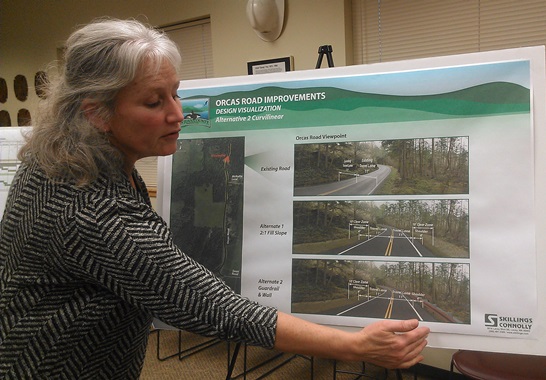
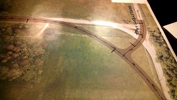
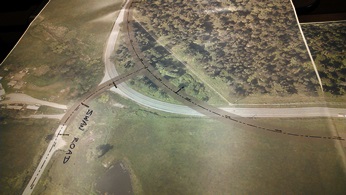
A vote taken by participants at the January public meeting indicated that 50% saw Alternative #2, the Curvilinear Alignment, as the best solution. This design widens the curve to the west at Swan Road and the curve to the south at Nordstrom Lane. (See photos)
A representative from the design engineering firm of Skillings Connolly said that he’d heard many new comments on Tuesday evening. One discussion centered around the proposal to increase the road shoulders just south of the Orcas Transfer Station, where property owners cut down many of the trees alongside the road last year.
Ken Katz, Orcas contractor and member of the Eastsound Planning Review Committee, questioned whether the four-foot shoulders on either side of the roadway were recommended or required. David Kau, architect, spoke of preserving the trees currently along the side of the road. The guardrails proposed in one scenario were also a concern for both tree protection and cyclists’ safety. Wilbur said she would research further the State Department of Transportation (DOT) standards, and also look into obtaining exemptions and/or a variance for Scenic Byways.
It was noted that McNallie Lane is considered an alternative “cyclists” route into Eastsound.
Among the displays were :
- designs proposed for Nordstrom Lane and Swan Road — the two intersections most dramatically affected by the proposal;
- comments from the public and responses from County Public Works;
- five-year timeline for progress of the project;
- photographic scenarios for the current situation and proposed changes;
- aerial views of the roadway;
- map of traffic accident “hot spots” and density.
The last exhibit indicated that, contrary to some public opinions, speed and alcohol are factors in only 10 or 20% respectively of accidents. The most common factor in accidents on Orcas Road has been distraction/inattention.
Along with County Engineer Rachel Dietzman, Public Works Staff Russ Harvey, project design manager Colin Huntemer and County Councilman Rick Hughes, former Councilman Richard Fralick attended as consultant to the county on this project. He said, “My role is to be the eyes and ears assuring that community concerns are heard and respected. We learned something from the Mt. Baker Road project, and the County wanted to be responsive to community needs. I’m impressed with the county’s willingness to listen.”
Wilbur said that the final design phase will begin the end of March, after comments and research have been incorporated. After designs are finalized, the appraisal and acquisition processes will begin. Construction is expected to start in 2017.
This road improvement project has been part of San Juan County’s Transportation Improvement Plan since at least 2008, Wilbur said. Every four years, a major road construction project is undertaken. In 2009, it was the Fisherman Bay Road on Lopez Island, in 2013, it was the Mt. Baker Road project on Orcas Island.
“The County has received CRAB funding [Washington State County Road Administration Board] to design road improvements on Orcas Road from Milepost 3.4 to Milepost 4.5. The total project cost is estimated at $2.875 million…Federal funds may be used in future phases of this project.
“Orcas Road is part of the San Juan Islands Scenic Byway and is the main road from the ferry landing toEastsound, Moran State Park and the east side of Orcas Island. This project stretch of road begins south of Nordstrom Lane and extends to north of McNallie Lane.” (from County Public Works Request for Proposal)
**If you are reading theOrcasonian for free, thank your fellow islanders. If you would like to support theOrcasonian CLICK HERE to set your modestly-priced, voluntary subscription. Otherwise, no worries; we’re happy to share with you.**







All new and improved road construction in the county should include separate lanes for pedestrians, bikes and other human powered transport. Let’s really make this county attractive to human powered tourists. The county attracts a lot of cyclists but the roads are all very unfriendly to pedestrians and cyclists. That should include this improvement. If all repairs, upgrades and new roads had such lanes over time we would build towards being able to ride or walk comfortably from the ferry landing to Moran State park!
Martin
Thank you, Margie, for such a good overview, and graphics for those who couldn’t attend.
Martin’s comment about a bike-way should be incorporated. Orcas Pathways, formed in 2002, conducted a survey in 2005 to assess community needs/wants for walking & cycling pathways, and held follow-up Hamlet meetings. In many areas, implementation would necessitate easements on private property. Information gained at those meetings should be added to further planning for pedestrian/cycle lanes on our roads.
Future guardrail placement, and even routine road maintenance must keep the possibility of these lane(s) in mind. They call it long range planning…….