
— by Lin McNulty —
 There is nothing the Public Works Department desires more in reference to any changes to Orcas Road between Nordstrom Lane and and McNallie Road than input from the public. A sparsely-attended meeting was held on Wednesday, January 14 at Eastsound Fire Station, in which it was blatantly apparent that no final decision has been made as to the best way to proceed, and that more of the community needs to weigh in.
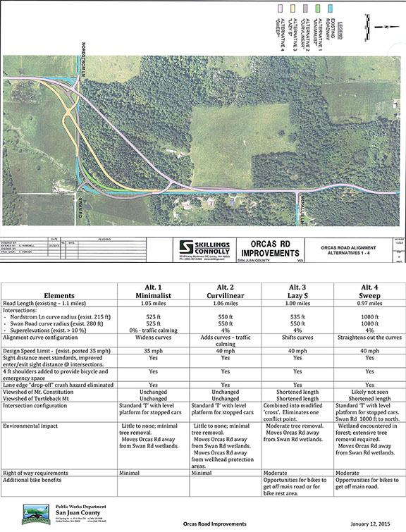
In the graphic above, four preliminary design alternatives are outlined. There is also a fifth alternative: do nothing. If this alternative—to do nothing—were to be chosen, the CRAB (County Road Administration Board) grant money that provides 90% of the upgrade costs would be returned and the County would be responsible for the costs of all work done to date.
The project is currently in Preliminary Design Phase I, with the following tasks to be completed:
- meet with adjacent property owners (done on Monday)
- present to Council (done on tuesday)
- collected traffic and structural data
- environmental data
- public outreach
Design Phase 2 typically takes a year, Phase 3 Property Acquisition also takes a year, but can be done hand-in-hand with Phase 2. The Phase 4 Construction will begin in 2016 at the earliest, or may stretch out until 2017.
[metaslider id=34101]
This perhaps begs the questions of “why Orcas Road” and “why this portion.” The project area is 1.1 miles, but visibility is dangerously limited in several portions. With a speed limit of 35 mph, 85% of traffic travels at 44 mph or less. Only 15% travel the posted speed limit. There have have been ten reported accidents on that stretch of roadway in 10 years, half of them with injuries. Not only is visibility limited, but the curve is too tight for good visibility. A driver should have a line of sight of 350-400 feet, With vertical site dips and no shoulders, the line of sight is only 200 feet in some areas. The Public Works crew walked the site earlier during the day and were completely surprised at the number of tire tracks that went off the road with shoulder from which to safely pull back onto the roadway.
As far as the aesthetics of any future plans, it is possible—and being considered—to integrate some bike pull-off “parks,” rest areas from which to view Turtleback and/or Mt. Constitusion, and/or to reclaim the area into its natural state.
Richad Fralick has assumed the position of Community Liaison and set to answer questions or relay information to the county. He can be reached at 376-2500.
It’s still very much a work in progress and open to public input. Additional information can be viewed online at the County website.

**If you are reading theOrcasonian for free, thank your fellow islanders. If you would like to support theOrcasonian CLICK HERE to set your modestly-priced, voluntary subscription. Otherwise, no worries; we’re happy to share with you.**


Be sure to add bicycle and pedestrian only lanes on ALL new road development and road improvements. All major roads on Orcas should have dedicated bicycle and pedestrian lanes.
Martin
This is certainly a stretch to pay attention to, as I’ve seen the aftermath of an accident where a motorcycle went off the road at the southernmost curve, jumped the fence and landed in the field.
I was not here when the road was modified at those corners…I assume they banked them and smoothed them out from right angles/ stops they had been. Am I correct? If one travels at the proper speed, these sight lines and bankings should work.
I’m curious how different they are from the curve at Lover’s Lane and Mt. Baker Rd. The real difference is the speed one travels at each curve…..
The other thing to note is that is seems the Public Works already has a commitment for the grant to do work in this area, and, if they do nothing, the money will go away. This happened with the guard rail project on Crow Valley Rd., where, if they had not done as long a stretch as proposed, they would have forfeited the residual money, rather than transfer it to another road project. Pity.
I applaud the shoulder/bicycle setback, and would think that would provide adequate “off-road” viewing for bicyclists, without needing “rest stops. However, if the Ride Share system is still happening, a pull-off or two could be for both purposes. Too bad the Federally supported Scenic By-Ways has no money to lend to this project.
This road project should be set in stone. Many people including my wife are of the opinion, no more asphalt. My wife, along with many others believe that the roads should remain rural without regard to how dangerous they might be. Many of us are waiting patiently for an independent bike lane to be installed throughout the islands. While an independent bike lane is needed, road improvements are also needed. The most dangerous piece of road on this island is the east west stretch between Nordstrom Lane and Swan Road. We are spending money to attract tourists to the Island. Many people and families bike the island, which has a very low environmental impact. Asking tourists who bike to endure the sheer terror of that stretch is not very hospitable. Tourist dollars make it possible for many businesses to stay open all winter. Anyone who has driven behind a mainlander heading south from Ships Bay Inn knows that people from off island do not do well with curves. They slow down and it puts a real brake on traffic flow. In that regard option four is best with some tweaks. One is that there should be left turn lanes heading north at Nordstrom Lane and heading south at Swan road. There is entirely too much to and fro from the ferry to stop the main line for someone making a left turn at either point. When the County declared Mt Baker Road a bypass they did not have the wisdom to install left turn lanes southbound at Washington Federal and Northbound at Country Corner. LETS NOT MAKE THAT MISTAKE AGAIN. (These missing left turn lanes should be on the list of future projects as well as paving Dolphin Bay Road.)
It is true that option four removes the most trees. We have no shortage of trees. I am a proud tree hugger but I am also pragmatic. The little section of forest the road would go through I believe is owned by the Land Bank. The old road between Nordstrom and Swan should be torn out and given to the farmer in exchange for the portion of their land we need. I was going to say that if option four is a stretch too far than it should be three, but three is spreading the footprint out pretty far. As for views we already have enough problems with sightseers slowing down and creating a traffic hazard. Perhaps a parking area (Scenic Lookout) could be added on the east side before the corner so that people could enjoy the view of Turtleback and the territorial view to the south. This area could be raised affording a better view of Turtleback and to the south. An informational board could be installed telling the history of Turtleback and the effort made by Islanders to preserve open space and being willing to pay more property tax as land is preserved and down zoned. It would set an example for how people are willing to be taxed more when there is a tangible improvement to their lives. In this case, less houses and more open space.
There should also be a sign asking tourists to pull over and let traffic pass when they are meandering on a leisurely tour of the island. I have noticed in my time in Washington State that almost no project is produced as well as it could be because of the shortage of money. I would rather see a project maxed out even if it means it would delay other projects down the road. I understand that this project, would mostly be funded by others, but having said that, It is high time that the road people seek input from the public as to what little tweaks our roads could use to make day to day driving easier. No one knows better than drivers who use the roads regularly. Tweaks are inexpensive and we would have to pay ourselves. If we had said list, we could start chipping away and budgeting for these improvements. I think that we should consider a sales tax bump dedicated to roads and our inevitable future dedicated bike lane. This additional revenue should be on top of our historical budgeting in this area.
One last thing, All the trees that are removed should be sold to low income people at a great discount (at least 50%) for firewood. In addition, when the Road crews remove downed or dangerous trees, that wood should also be sold to the needy. The road crews should not be taking the wood for themselves. Free wood is NOT a perk of the job. On another note for those who have not heard, our son Oliver last October, at the age of 21 and one week old was hired to play cello with The Boston Symphony next season. He will be in The Chamber Music Festival this summer.
Irrespective of the final alignment chosen, it has been my fervent hope, expressed strongly to our previous SJCDPWs director, that this segment of Orcas Road be designed to include a dedicated bike lane, and serve as a prototype for future road improvements between Eastsound and Orcas Landing.
I personally cannot believe there is an option of “do nothing”.
This stretch of road is a “nightmare waiting to happen” and the fact that the nightmare is now openly being discussed as it is, opens up the county(us) to some legal responsibility if something horrible were to happen. Let’s fix it and soon!
Maggie
Like Fred Klein said, this segment of Orcas Road must include a dedicated bike lane, and serve as a prototype for future road improvements between Eastsound and Orcas Landing.
The completed Mt. Baker Road should have included this also; not just a paved four foot shoulder, but an actual signed bike lane. The reason that it was not done was that the county made a mistake by misdetermining that the shoulder had to be five feet wide to qualify as a bike lane. When I pointed out to them in the official code that the bike lane only had to be four feet wide, they did NOTHING to rectify it even though there was plenty of time left in the design stage!
One of the questions that I have is how ten accidents on that stretch of roadway in 10 years compares to other roads or to the total number of trips that occur over that road. I seem to recall that virtually all of the accidents in question resulted from DUI and/or excessive speed.