||| FROM KOMO TV |||
When severe weather hits western Washington, where you live can make a big difference in the impact to you and your family.
To give a more accurate and more detailed forecast, meteorologists at the National Weather Service office in Seattle are about to make a change in how they issue forecasts.
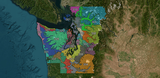
Western Washington is divided into what are called the “public zones” for forecasting. Based on this map, watches, warnings, advisories, and special weather statements are issued for areas. Many of the zone borders follow county lines.
The problem comes with our many microclimates in western Washington. Within a single county there can be varying elevations, terrains and what the weather service calls “localized weather effects.”
Under the current system, NWS said an entire zone may be alerted to a severe weather event when only a small portion of the zone is expected to be impacted. That’s why a change is coming on March 18th.
The map of the new “public zones” in western Washington more closely follows elevation levels, localized climate, major transportation routes, and where people live. The goal is to improve the accuracy of watches, warnings, and advisories.
Government forecasters believe the new “public zone” map will be especially helpful when forecasting Puget Sound Convergence Zone snowfall events, snowstorms where communities in mountain valleys are not impacted, coastal flooding and tsunami events.
That should make forecasts on TV, radio, and online more accurate this year.
**If you are reading theOrcasonian for free, thank your fellow islanders. If you would like to support theOrcasonian CLICK HERE to set your modestly-priced, voluntary subscription. Otherwise, no worries; we’re happy to share with you.**

