— by Michael Riordan for Whatcomwatch.org —

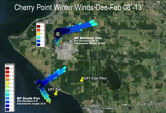
Strong winter winds at Cherry Point blow from the northeast and southeast making Cherry Point a hazardous site for a coal terminal
From a meteorologist’s perspective, Cherry Point is a terrible site for a coal terminal, for it endures some of the fiercest winds in Washington state.
These wintry gales out of the northeast have been obvious to my wife and me ever since we purchased our house on Orcas Island’s north side, facing across Georgia Strait to this cobble-strewn promontory. From our deck we can look out over wind-whipped waters and watch the pallid plumes that normally waft above the BP Refinery north of the point stream our way instead.
So when I first encountered SSA Marine’s plans to build a gargantuan coal terminal at the point, I said to her, “They can’t be serious. This must be a joke!”
But to my surprise and dismay, they were. And it wasn’t.
Not only would this project be the largest coal terminal in North America, shipping more than 50 million tons of the dusty Powder River Basin (PRB) coal annually, according to project documents. The Gateway Pacific Terminal (GPT) would also include over 80 acres of uncovered storage piles towering more than 60 feet high, holding up to 3 million tons of coal nakedly exposed to these gales.
A brief dive into the meteorology literature confirmed my worst fears. A 1995 article in Monthly Weather Review by renowned University of Washington atmospheric scientist Cliff Mass (author of “The Weather of the Pacific Northwest”) and colleagues concluded that gale-force winds could be expected there every winter. These frigid, blustery winds blow through northern Whatcom County between Blaine and Bellingham because the Fraser River Gap to the northeast channels air flowing from high-pressure systems over inland British Columbia toward the Pacific Ocean, accelerating the wind’s speed as it surges through the narrow breach. As Mass et al. stated, “Strong (greater than 25 m/s) outflows of arctic air through the Fraser Gap into Western Washington occur once or twice a year.”
Fraser Gap Winds
And these Fraser Gap winds can occasionally hit hurricane force! That’s what clobbered the area on Dec. 28, 1990, and was the subject of this paper. Winds up to 100 mph raged from Whatcom County shores across Georgia Strait, slammed into the northeast side of Orcas Island, and converted dense, verdant forests there into huge tangles of downed timber. Fortunately, there were no six-story-high piles of coal in the way of this torrent.
(To read the full article, go to https://www.whatcomwatch.org/php/WW_open.php?id=1822)
A Ph.D. physicist from MIT, Michael Riordan is author of “The Hunting of the Quark” and coauthor of “Crystal Fire” and “The Solar Home Book.” He writes about science, technology and public policy from Orcas Island.
**If you are reading theOrcasonian for free, thank your fellow islanders. If you would like to support theOrcasonian CLICK HERE to set your modestly-priced, voluntary subscription. Otherwise, no worries; we’re happy to share with you.**


In the end, it may be economic and political winds that doom west coast coal export terminals. Global coal producers assumed that China’s coal demand would continue to increase in a linear fashion. They were wrong. Logistics will determine that North American producers’ China export plans are culled first. There’s more going on behind the scenes than just the market price for coal with China’s economy transitioning from a heavy industrial output phase to one focused on domestic consumption. There’s plenty of future energy demand upside in China and greater Asia, but I don’t think it prominently features US coal.
Meanwhile, down on the US Gulf Coast, the Obama administration and the energy industry have been working closely to fast track LNG export infrastructure. Six major export terminal projects are approved and in development with more in planning stages. The first, Cheniere Energy’s Sabine Pass (LA) LNG terminal, is currently on schedule to open Q1 2016 with export capacity of 2.76 bcfd. China will be a major, though not exclusive, customer for US LNG.
By 2018, US LNG exports to China will be the major trans-Pacific natural resource story, with the prospect of coal exports fading away. Not coincidentally, the investment in LNG export infrastructure looks likely to become a major legacy of the Obama administration.
Seems like a “meteorologist” would also be aware of another factor that this area (PNW) is known for – rain. Dust of any kind just doesn’t seem to be much of a problem during our famously soggy winter months. Maybe that is the reason for the “uncovered” piles of coal? I’m sure you can look up the monthly rainfall totals for the Cherry Pt. area as well as the winds.
I’d bet that’s what SSA Marine’s planners figured, too, when they decided to build North America’s largest coal terminal smack in the midst of one of Washington State’s windiest locations. But if you were to follow the link and read further in the Whatcom Watch article, you’d learn that Fraser Gap winds from the northeast are extremely DRY winds that often blow for days on end. People who live on the north side of Orcas Island know this all too well. That gives the winds plenty of time to dry out the surface layer of coal and blow it our way.
The dry COLD Fraser winds also tend to freeze anything with any water content. Ever tried to dig up a frozen pipe during one of our northeasters? Those coal piles will be solid as a rock. We’ll just have to agree to disagree about this “dust” problem in the middle of winter here.
The mining industry typically adds freeze conditioning agents to coal and minerals in the winter to prevent freezing material from causing problems with logistics operations. The amount of agent added will be relative to the moisture content of the material. Salts like calcium chloride are typically used as a freeze point depressant and to weaken ice crystal integrity. Freeze conditioning agents may also provide some dust mitigation benefits.