||| FROM NATURAL RESOURCES CONSERVATION SERVICE |||
After the very encouraging snowstorms in December, January flatlined, receiving only 63% of normal total mountain precipitation for the month. The state received several resuscitative events that represented hope. However most carried little precipitation with warm temperatures that hampered true to normal snow accumulations. Fortunately, most of these events were followed by cold snaps, locking the moisture into the snowpack, a benefit to spring runoff. As recreationists look to the next couple of months to help prolong the season with fresh powder, water managers are hoping to continue to build the snow water content for downstream use later in the year.
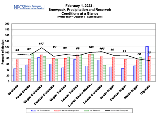
The most recent forecast through late-February shows a probability for below normal temperatures and slightly above normal precipitation. NWS 3-month (February, March, and April) forecast indicates below normal temperatures and above normal precipitation which is indicative of the forecasted Enso La Nina #3. The US Drought Monitor continues to show improvement each month with only a trace of DO which stretches from the central part of the state up through and over the norther teer.
More information on the Washington Snow Survey & Water Supply Program is available here and the full February report is available, directly, here.

**If you are reading theOrcasonian for free, thank your fellow islanders. If you would like to support theOrcasonian CLICK HERE to set your modestly-priced, voluntary subscription. Otherwise, no worries; we’re happy to share with you.**