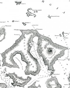
The Wilkes Exploring Expedition Map (1841). The "islands" of Adolphus and Gordon are off the northwest tip of Orcas Island. Map courtesy of Peter Fisher
By Tom Welch
Adolphus & Gordon Islands
Sandy beaches line the shoreline where a little-known type of palm tree gently wafts in the island breeze, and sun-dappled ponds covered in lily pads dot the inland island landscape. Unusual for the San Juan Islands, the gentle knolls covered in rich native grasses turn gold and purple in the nearly-tropical sunlight. Flashes of mica and quartz speak of the rich veins of gold and silver just below the verdant surface, and fossils of yet-unknown species of dinosaurs dot the occasional rocky outcrops. Butterflies and hummingbirds in a myriad of colors compete with the brilliant indigo wings of the fabled San Juan Snaptail, and giant Atlas deer swing their incredible antlers as they graze in peace and plenty.
Visitors stroll among the flowers as their boats bob in the gentle swell of the azure coves tucked along the shoreline, while sea lions and walruses bask on the quiet beaches. Narwhales school along the western shore as they head back to arctic waters every fall, and albatrosses soar above the pristine waters that lie between these fabulous islands. Midway between Waldron and Sucia Islands, these are the mysterious wonderlands known as Adolphus and Gordon Islands, the 173rd and 174th of the San Juan Islands.
Sound alluring, yet completely incredible? You’re right – neither one actually exists, save for those notations on the official U.S. Government charts compiled by the U.S. Exploring Expedition in 1841. Commanded by Lieutenant Charles Wilkes, the ‘U.S. Ex Ex’, as it was called, surveyed, charted, and explored the San Juan Islands during their epic voyage of discovery one hundred and seventy years ago.
The first international expression of U.S. naval power, the Exploring Expedition counted the discovery of Antarctica, the survey and mapping of the Fiji and other South Sea Islands, the exploration of the Hawaiian Islands, and the first mapping of the Northwest Coast of America among their signal accomplishments. The thousands of items of art and artifacts brought back to the United States by the Expedition became the foundation collection of our ‘national museum’, the Smithsonian Institution.
So, why are these islands on the charts of the U.S. Ex Ex? How did a rigorously scientific Expedition make such an egregious error on official U.S. Navy charts, and why? There’s a simple answer, and it has to do with those two familiar, yet hard-to-define, concepts: ‘Correct Behavior’ and ‘Respect.’
It seems that Wilkes, Commander of the U.S. Ex Ex, was such a martinet and disciplinarian that every little mistake his officers and men made was cause for punishment, often carried to ridiculous lengths. His officers and men grew to detest him during the four year voyage around the world – most particularly the Midshipmen charged with recording the discoveries on the official charts of the Expedition.
Intent on embarrassing Wilkes, they drew the islands of Adolphus and Gordon on the charts of the Navy Archipelago, which is what Wilkes named the San Juan Islands. Knowing that the charts became official government documents once they were signed by the Commander, the Midshipmen intentionally drew fictitious islands on the charts…and Wilkes signed them.
**If you are reading theOrcasonian for free, thank your fellow islanders. If you would like to support theOrcasonian CLICK HERE to set your modestly-priced, voluntary subscription. Otherwise, no worries; we’re happy to share with you.**


If you would enjoy a full history of the US South Seas Exploring Expedition (the Ex Ex) and particularly on Captain Charles Wilkes, read “Sea of Glory” by Nathaniel Philbrick.
How did Wilkes become the way he was ? Philosopher Henry David Thoreau was fascinated by Wilkes and the Ex Ex, and Philbrick quotes from the final chapter of Walden: “with all its parade and expense, but an indirect recognition of the fact that there are continents and seas in the moral world, to which every man is an isthmus or an inlet, het unexplored by him, but that it is easier to sail many thousand miles through cold and storm and cannibals, in a government ship, with five hundred men and boys to assist one, than it is to explore the private sea, the Atlantic and Pacific Oceans of one’s being alone.”